
1940 - U.S. Rte 2, Pine Tree Trail (actual photo)

PTT's"CC"LLC presents: pinetreetrail.com
Maine's #1 source of information about the Pine Tree Trail

The Story
of
Maine's
Pine Tree Trail

Unbelievably, unearthing an old road sign was what led to the discovery and revival of Maine's forgotten 500-mile Trail .
In the mid-1930s, as Maine worked its way out of the Great Depression, the state began looking for new ways to bring in revenue through tourism. In 1936, "VACATIONLAND" appeared on Maine license plates for the very first time.
A year later, in 1937, the 88th Maine State Legislature passed an act designating a certain road as the "Pine Tree Trail" (Chapter 43, approved March 29, 1937) — a route running from Portland to Fort Kent. (Some maps, atlases, and newspapers of the era describe it instead as running from Kittery to Fort Kent.) Stretching nearly 500 miles, it was an inland route — running north from Portland through Auburn, Lewiston, Augusta, Waterville, and Bangor, on toward Houlton and Fort Kent — threading through Maine's towns and cities, its lake regions, forests, and farmlands.
Then came the disruption of World War II, and with the new road planning that followed, the Pine Tree Trail slipped quietly out of memory. In time, it became known as "Maine's Forgotten Trail."
And then...
One day in 2012, a Mainer came across what looked like an old, rusted, bent-up piece of sheet metal — riddled with bullet holes — lying along Route 2 in Molunkus. Brushing away the leaves, rocks, and dirt and looking closer, he realized it was a steel embossed road sign. It read "Pine Tree Trail," with an evergreen tree embossed at its center. The sign was in such rough shape that he nearly threw it back, but something made him hold on to it. He kept it for years.
During mud season in the spring of 2019, he finally set out to learn the story behind the sign — the route, its history, and whatever others might still remember. He and his fiancée went looking, and what struck them was how little information was out there. So he had an idea: bring the route back, and with it the recognition and the benefits it could bring to Maine. It would become known as the Pine Tree Trail Project.
Together, Nate Nipula and his fiancée, Roberta "Robbie" McKay, set out to invite the trail community to help re-establish the route — rallying local businesses and individuals, who came aboard as "Trailblazers," to raise the funds needed to sign it once again. Because the effort was not a non-profit, every dollar raised went directly into a dedicated account set up through a well-known and respected local sign manufacturer.
In February 2020, the two met with former Secretary of State Matt Dunlap, who confirmed the route was "still the law of the land" — it had never been repealed, only left un-signed and off the maps for more than seventy years. They met with legislators and with Director of Tourism Steve Lyons, who called the Pine Tree Trail "like Maine's own Route 66."
And then COVID arrived and nearly brought everything to a halt. Fortunately, the work pressed on. In 2022, the first modern, Maine DOT-approved Pine Tree Trail signs were manufactured and began going up along the route. And in 2023 — for the first time in decades — the Trail reappeared on the official Maine State map, and soon after in the DeLorme Maine Atlas & Gazetteer.
In reviving the Pine Tree Trail, the Project has brought new hope to the communities along its length, and to Maine itself — the Pine Tree State. As the Trail nears its 90th anniversary on March 29, 2027, the work continues: putting inland Maine back on the map, one community at a time.
A Facebook group, "Maine's Pine Tree Trail Community," is now the place to gather and share memories and happenings all along its route.
MAINE’S PINE TREE TRAIL
AN ACT
AS PASSED BY THE
Eighty-eighth Legislature
OF THE
STATE OF MAINE
1937
Chapter 43
An Act Designating a Certain Road as "Pine Tree Trail."
Be it enacted by the People of the State of Maine, as follows:
"Pine Tree Trail" designated. The road leading from Portland through Auburn, Lewiston, Winthrop, Augusta, Belgrade, Oakland, Waterville, Pittsfield, Newport, Bangor, Orono, Old Town, Lincoln, Mattawamkeag, and Macwahoc, Route A from Macwahoc to Houlton by way of Haynesville Route B-from Macwahoc to Houlton by way of Island Falls, from Houlton to Mars Hill,-Route A from Mars Hill to Fort Kent by way of Presque Isle, Caribou, and Van Buren-Route B-from Mars Hill by way of Ft. Fairfield, Limestone and Van Buren, is hereby designated as the "Pine Tree Trail." Approved March 29th 1937
https://lldc.mainelegislature.org/Open/Laws/1937/1937_PS_c043.pdf
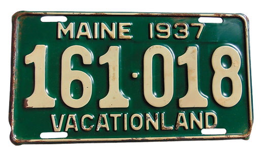


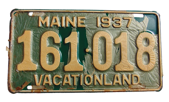
Photo of new old stock 1937 Maine license plates. Original masking on one plate.
Photo: Road Rte.2/ Pine Tree Trail Molunkus Twp./ Macwahoc Plt. line